


26.01.2014 - Meillac

babeth35
User
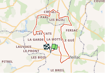

Length
17.3 km

Max alt
93 m

Uphill gradient
148 m
Km-Effort
19.3 km

Min alt
31 m

Downhill gradient
148 m
Boucle
Yes
Creation date :
2014-12-10 00:00:00.0
Updated on :
2020-07-20 16:10:15.78
4h18
Difficulty : Very easy

FREE GPS app for hiking
 SityTrail
IGN / Geographical institutes
SityTrail Plus
The world is yours!
About
Trail Walking of 17.3 km to be discovered at Brittany, Ille-et-Vilaine, Meillac. This trail is proposed by babeth35.
Positioning
Country:
France
Region :
Brittany
Department/Province :
Ille-et-Vilaine
Municipality :
Meillac
Location:
Unknown
Start:(Dec)
Start:(UTM)
585869 ; 5363082 (30U) N.
Comments