


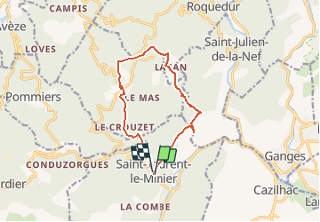
SAINT-LAURENT-LE-MINIER – OISELETTE - 11.7Km - 04h30 - Dénivelé 650 m

dansmabulle
User


4h07
Difficulty : Medium

FREE GPS app for hiking
 SityTrail
IGN / Geographical institutes
SityTrail Plus
The world is yours!
About
Trail Walking of 11.7 km to be discovered at Occitania, Gard, Saint-Laurent-le-Minier. This trail is proposed by dansmabulle.
Description
Départ randonnée : Village de St-Laurent-le-Minier (Gard 30)
Depuis St-Laurent-le-Minier, vous montez jusqu'au sommet de l'Oiselette en passant par Lacam.
Vous revenez au point de départ en passant par St-Bresson.
Bonne randonnée
Positioning
Comments