


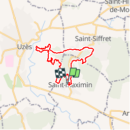
SAINT-MAXIMIN - 13.9Km - 04h40 - Dénivelé 270 m

dansmabulle
User


3h46
Difficulty : Medium

FREE GPS app for hiking
 SityTrail
IGN / Geographical institutes
SityTrail Plus
The world is yours!
About
Trail Walking of 13.9 km to be discovered at Occitania, Gard, Saint-Maximin. This trail is proposed by dansmabulle.
Description
Départ randonnée :
Village de Saint-Maximin (Gard 30) Petite randonnée au départ de SAINT MAXIMIN dans la garrigue en direction de la vallée de l'Eure à UZES.Retour par SAINT SIFFRET. Tracé tiré du carto guide "Entre Rhône et Gardon".Aucune difficulté à noter.Bonne randonnée
Positioning
Comments