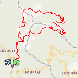
SAINT ROMAN DE CODIERES - COL DES FOSSES - 13.8Km 05h00 - Dénivelé 625 m

dansmabulle
User


4h33
Difficulty : Difficult

FREE GPS app for hiking
 SityTrail
IGN / Geographical institutes
SityTrail Plus
The world is yours!
About
Trail Walking of 13.8 km to be discovered at Occitania, Gard, Saint-Roman-de-Codières. This trail is proposed by dansmabulle.
Description
Départ randonnée :
A la sortie de Saint-Roman-de-codières en allant vers le nord(Gard 30) Saint Roman de Codières : Le col des Fosses.Belle ballade à faire par beau temps de préférence pour admirer les points de vue sur les Cévennes, le Mont Ventoux, les Alpes, le Mont Aigoual, à travers chênes et châtaigniers sans oublier les menhirs et nombreux blocs de granit. Bonne randonnée.
Positioning
Comments