


02-06-20-RIF du 27.06.2020

bene_dictus77
User

Length
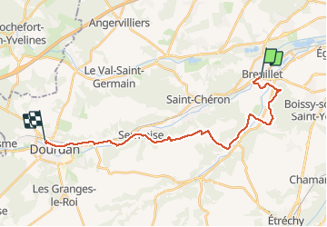
22 km

Max alt
155 m

Uphill gradient
367 m
Km-Effort
27 km

Min alt
57 m

Downhill gradient
308 m
Boucle
No
Creation date :
2020-06-27 11:10:17.885
Updated on :
2020-06-28 10:07:36.853
5h27
Difficulty : Very easy

FREE GPS app for hiking
 SityTrail
IGN / Geographical institutes
SityTrail Plus
The world is yours!
About
Trail Walking of 22 km to be discovered at Ile-de-France, Essonne, Breuillet. This trail is proposed by bene_dictus77.
Description
De Breuillet Village jusqu'à Dourdan
Positioning
Country:
France
Region :
Ile-de-France
Department/Province :
Essonne
Municipality :
Breuillet
Location:
Unknown
Start:(Dec)
Start:(UTM)
438891 ; 5379414 (31U) N.
Comments