


Circuit du Seuil

frizou83
User
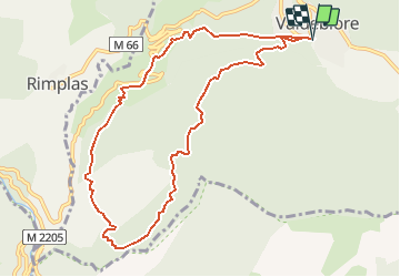

Length
10.5 km

Max alt
1071 m

Uphill gradient
573 m
Km-Effort
18.1 km

Min alt
671 m

Downhill gradient
572 m
Boucle
Yes
Creation date :
2020-06-28 06:18:13.512
Updated on :
2020-06-30 16:24:17.432
3h40
Difficulty : Difficult

FREE GPS app for hiking
 SityTrail
IGN / Geographical institutes
SityTrail Plus
The world is yours!
About
Trail Walking of 10.5 km to be discovered at Provence-Alpes-Côte d'Azur, Maritime Alps, Valdeblore. This trail is proposed by frizou83.
Positioning
Country:
France
Region :
Provence-Alpes-Côte d'Azur
Department/Province :
Maritime Alps
Municipality :
Valdeblore
Location:
Unknown
Start:(Dec)
Start:(UTM)
353538 ; 4881152 (32T) N.
Comments