


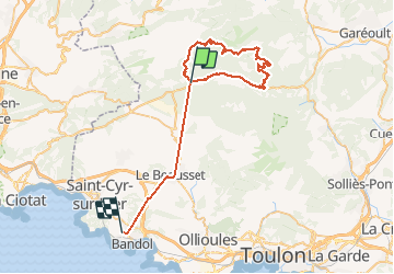
Signes casse fourche

Franz BOFFARD
User

Length
53 km

Max alt
871 m

Uphill gradient
1479 m
Km-Effort
74 km

Min alt
48 m

Downhill gradient
1815 m
Boucle
No
Creation date :
2020-06-28 06:36:48.0
Updated on :
2020-06-28 11:07:46.151
4h30
Difficulty :

FREE GPS app for hiking
 SityTrail
IGN / Geographical institutes
SityTrail Plus
The world is yours!
About
Trail Mountain bike of 53 km to be discovered at Provence-Alpes-Côte d'Azur, Var, Signes. This trail is proposed by Franz BOFFARD.
Positioning
Country:
France
Region :
Provence-Alpes-Côte d'Azur
Department/Province :
Var
Municipality :
Signes
Location:
Unknown
Start:(Dec)
Start:(UTM)
729364 ; 4796043 (31T) N.
Comments