


Col de la Madeleine

frizou83
User

Length
10.9 km

Max alt
1860 m

Uphill gradient
637 m
Km-Effort
19.4 km

Min alt
1283 m

Downhill gradient
643 m
Boucle
Yes
Creation date :
2020-06-28 15:44:33.738
Updated on :
2020-06-28 15:45:23.718
3h55
Difficulty : Difficult

FREE GPS app for hiking
 SityTrail
IGN / Geographical institutes
SityTrail Plus
The world is yours!
About
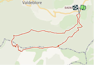
Trail Walking of 10.9 km to be discovered at Provence-Alpes-Côte d'Azur, Maritime Alps, Valdeblore. This trail is proposed by frizou83.
Positioning
Country:
France
Region :
Provence-Alpes-Côte d'Azur
Department/Province :
Maritime Alps
Municipality :
Valdeblore
Location:
Unknown
Start:(Dec)
Start:(UTM)
356112 ; 4880713 (32T) N.
Comments