Trail Walking Saint-André-en-Vivarais - St André Calvaire Piaron - Photo
 tartane1
tartane1

User

© OpenStreetMap contributors
Length
Length
6.5 km
Max alt
Max alt
1170 m
Uphill gradient
Uphill gradient
148 m
Km-Effort
Km-Effort  
8.5 km
Min alt
Min alt
1070 m
Downhill gradient
Downhill gradient
149 m
Boucle
Boucle
Yes
Creation date :
2020-06-28 16:56:27.038
Updated on :
2020-06-28 17:01:50.991

(0 Reviews)

Walking
Walking
1h49
Difficulty : Medium

Scan this QR Code to open this trail in the SityTrail application

FREE GPS app for hiking

Logo SityTrail SityTrail

IGN / Geographical institutes

Download SityTrail from the App Store Download SityTrail from Google Play

Logo SityTrail SityTrail World

The world is yours!

Download SityTrail from the App Store Download SityTrail from Google Play Download SityTrail on Huawei AppGallery

About

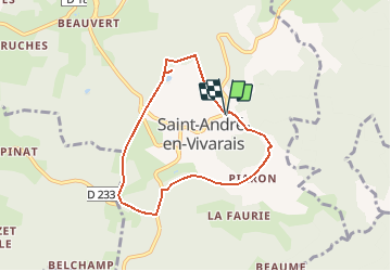
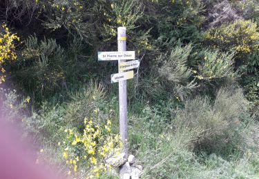
Trail Walking of 6.5 km to be discovered at Auvergne-Rhône-Alpes, Ardèche, Saint-André-en-Vivarais. This trail is proposed by tartane1.

Description

Rando dans les sous bois, agréable et facile.
Départ et arrivée au  Calvaire,  au dessus du village.Coin pique -nique.

Elevation profile

Positioning

Country:
France
Region :
Auvergne-Rhône-Alpes
Department/Province :
Ardèche
Municipality :
Saint-André-en-Vivarais
Location:
Unknown
Start:(UTM)
611417 ; 4997542 (31T) N.

Trails nearby

Trail Walking Montregard - lalyret  - Photo
Walking
poterie

Walking

Difficult
(1)
Montregard, Auvergne-Rhône-Alpes, Haute-Loire, France
10.8 km | 14.6 km-effort
3h 18min
Yes
Trail Walking Saint-André-en-Vivarais - 43 st André en vivarais - Photo
Walking
himba26100

Walking

Easy
Saint-André-en-Vivarais, Auvergne-Rhône-Alpes, Ardèche, France
12.7 km | 17 km-effort
4h 33min
Yes
Trail Snowshoes Le Mas-de-Tence - Coup d'oeil à Montregard - Photo
Snowshoes
tracegps

Snowshoes

Medium
Le Mas-de-Tence, Auvergne-Rhône-Alpes, Haute-Loire, France
10.4 km | 13.2 km-effort
3h 0min
Yes
Trail Mountain bike Le Mas-de-Tence - Coup d'oeil à Montregard - Photo
Mountain bike
tracegps

Mountain bike

Medium
Le Mas-de-Tence, Auvergne-Rhône-Alpes, Haute-Loire, France
10.4 km | 13.2 km-effort
1h 0min
Yes
Trail Walking Le Mas-de-Tence - Coup d'oeil à Montregard - Photo
Walking
tracegps

Walking

Medium
Le Mas-de-Tence, Auvergne-Rhône-Alpes, Haute-Loire, France
10.4 km | 13.2 km-effort
2h 30min
Yes
Trail Mountain bike Le Mas-de-Tence - Aux Portes du Mas de Tence - Photo
Mountain bike
tracegps

Mountain bike

Medium
Le Mas-de-Tence, Auvergne-Rhône-Alpes, Haute-Loire, France
8.3 km | 11.4 km-effort
1h 0min
Yes
Trail Walking Le Mas-de-Tence - Aux Portes du Mas de Tence - Photo
Walking
tracegps

Walking

Medium
Le Mas-de-Tence, Auvergne-Rhône-Alpes, Haute-Loire, France
8.3 km | 11.4 km-effort
2h 0min
Yes
Trail On foot Saint-Pierre-sur-Doux - st Pierre sur doux - Photo
On foot
TOULAUDIN

On foot

Medium
Saint-Pierre-sur-Doux, Auvergne-Rhône-Alpes, Ardèche, France
23 km | 35 km-effort
Unknown
Yes
Trail Walking Saint-Bonnet-le-Froid - Chemin de Saint Régis: Saint Bonnet le Froid - Montfaucon en Velay - Photo
Walking
tracegps

Walking

Difficult
Saint-Bonnet-le-Froid, Auvergne-Rhône-Alpes, Haute-Loire, France
24 km | 34 km-effort
8h 45min
No


Close
My subscriptions