


le pas de l'Allier via sant Martin Vercors

marcagif
User
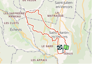

Length
18.1 km

Max alt
1269 m

Uphill gradient
736 m
Km-Effort
28 km

Min alt
696 m

Downhill gradient
729 m
Boucle
Yes
Creation date :
2020-06-29 07:52:19.134
Updated on :
2020-06-29 16:00:02.278
5h05
Difficulty : Easy

FREE GPS app for hiking
 SityTrail
IGN / Geographical institutes
SityTrail Plus
The world is yours!
About
Trail Walking of 18.1 km to be discovered at Auvergne-Rhône-Alpes, Drôme, Saint-Martin-en-Vercors. This trail is proposed by marcagif.
Description
départ du camping les morceaux. les Tourtres
Positioning
Country:
France
Region :
Auvergne-Rhône-Alpes
Department/Province :
Drôme
Municipality :
Saint-Martin-en-Vercors
Location:
Unknown
Start:(Dec)
Start:(UTM)
692887 ; 4986311 (31T) N.
Comments