


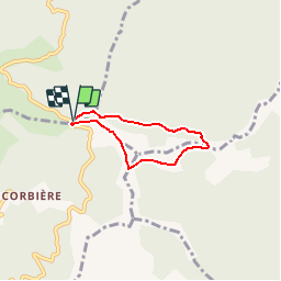
30 - CAMP-REDON - Sentier du Rocher de l'Aigle - 4.2 Km - 1h30 - D 280 m

dansmabulle
User

Length
4.2 km

Max alt
1144 m

Uphill gradient
240 m
Km-Effort
7.5 km

Min alt
890 m

Downhill gradient
246 m
Boucle
Yes
Creation date :
2014-12-10 00:00:00.0
Updated on :
2014-12-10 00:00:00.0
1h35
Difficulty : Medium

FREE GPS app for hiking
 SityTrail
IGN / Geographical institutes
SityTrail Plus
The world is yours!
About
Trail Walking of 4.2 km to be discovered at Occitania, Gard, Les Plantiers. This trail is proposed by dansmabulle.
Positioning
Country:
France
Region :
Occitania
Department/Province :
Gard
Municipality :
Les Plantiers
Location:
Unknown
Start:(Dec)
Start:(UTM)
559600 ; 4880780 (31T) N.
Comments