


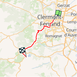
clermont - aydat

ARVIEU
User

Length
24 km

Max alt
1032 m

Uphill gradient
827 m
Km-Effort
34 km

Min alt
360 m

Downhill gradient
339 m
Boucle
No
Creation date :
2014-12-10 00:00:00.0
Updated on :
2014-12-10 00:00:00.0
2h16
Difficulty : Medium

FREE GPS app for hiking
 SityTrail
IGN / Geographical institutes
SityTrail Plus
The world is yours!
About
Trail Mountain bike of 24 km to be discovered at Auvergne-Rhône-Alpes, Puy-de-Dôme, Clermont-Ferrand. This trail is proposed by ARVIEU.
Description
clermont - aydat par les puys
Positioning
Country:
France
Region :
Auvergne-Rhône-Alpes
Department/Province :
Puy-de-Dôme
Municipality :
Clermont-Ferrand
Location:
Unknown
Start:(Dec)
Start:(UTM)
507806 ; 5069527 (31T) N.
Comments