


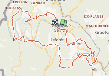
Vresse 30K/1500D+

DenisLaoureux
User


--
Difficulty : Difficult

FREE GPS app for hiking
 SityTrail
IGN / Geographical institutes
SityTrail Plus
The world is yours!
About
Trail Trail of 30 km to be discovered at Wallonia, Namur, Vresse-sur-Semois. This trail is proposed by DenisLaoureux.
Description
Trace reliant les principaux murs autour de Vresse par des sentiers alternant portions roulantes et sections techniques. La monotrace en montée après les Blanches Roches est somptueuse. Le chemin du premier mur de Alle-sur-Semois passe par un bloc rocheux en montant et par le sentier au pied de ce dernier en descendant (là, on fait un a/r juste pour le fun). Le final emprunte la ligne de crête de Charière après le 2e mur de Alle-sur-Semois pour redescendre sur Vresse. Beau et brutal.
Positioning
Comments