


Lomont

tiene
User

Length
43 km

Max alt
834 m

Uphill gradient
1027 m
Km-Effort
56 km

Min alt
329 m

Downhill gradient
1027 m
Boucle
Yes
Creation date :
2020-06-30 11:40:27.667
Updated on :
2020-07-02 19:26:12.011
3h39
Difficulty : Very difficult

FREE GPS app for hiking
 SityTrail
IGN / Geographical institutes
SityTrail Plus
The world is yours!
About
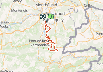
Trail Mountain bike of 43 km to be discovered at Bourgogne-Franche-Comté, Doubs, Mandeure. This trail is proposed by tiene.
Positioning
Country:
France
Region :
Bourgogne-Franche-Comté
Department/Province :
Doubs
Municipality :
Mandeure
Location:
Unknown
Start:(Dec)
Start:(UTM)
334317 ; 5257740 (32T) N.
Comments