


Suc d'Ourseyre

pb07
User
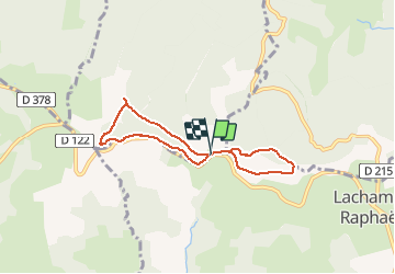

Length
6 km

Max alt
1484 m

Uphill gradient
180 m
Km-Effort
8.4 km

Min alt
1361 m

Downhill gradient
182 m
Boucle
Yes
Creation date :
2020-06-30 12:15:09.94
Updated on :
2020-06-30 16:40:11.581
2h27
Difficulty : Easy

FREE GPS app for hiking
 SityTrail
IGN / Geographical institutes
SityTrail Plus
The world is yours!
About
Trail Walking of 6 km to be discovered at Auvergne-Rhône-Alpes, Ardèche, Saint-Andéol-de-Fourchades. This trail is proposed by pb07.
Positioning
Country:
France
Region :
Auvergne-Rhône-Alpes
Department/Province :
Ardèche
Municipality :
Saint-Andéol-de-Fourchades
Location:
Unknown
Start:(Dec)
Start:(UTM)
600014 ; 4963246 (31T) N.
Comments