


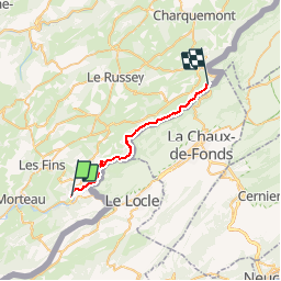
GTJ Villiers le Lac La Rasse

svp59
User

Length
22 km

Max alt
904 m

Uphill gradient
591 m
Km-Effort
30 km

Min alt
621 m

Downhill gradient
724 m
Boucle
No
Creation date :
2014-12-10 00:00:00.0
Updated on :
2014-12-10 00:00:00.0
6h54
Difficulty : Medium

FREE GPS app for hiking
 SityTrail
IGN / Geographical institutes
SityTrail Plus
The world is yours!
About
Trail Walking of 22 km to be discovered at Bourgogne-Franche-Comté, Doubs, Villers-le-Lac. This trail is proposed by svp59.
Description
Villiers le Lac La Rasse
Positioning
Country:
France
Region :
Bourgogne-Franche-Comté
Department/Province :
Doubs
Municipality :
Villers-le-Lac
Location:
Unknown
Start:(Dec)
Start:(UTM)
323059 ; 5214396 (32T) N.
Comments