


Baus de la Frema

frizou83
User
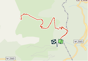

Length
6.2 km

Max alt
2225 m

Uphill gradient
561 m
Km-Effort
13.7 km

Min alt
1664 m

Downhill gradient
559 m
Boucle
Yes
Creation date :
2020-07-01 15:30:26.91
Updated on :
2020-07-07 15:54:59.373
3h37
Difficulty : Difficult

FREE GPS app for hiking
 SityTrail
IGN / Geographical institutes
SityTrail Plus
The world is yours!
About
Trail Walking of 6.2 km to be discovered at Provence-Alpes-Côte d'Azur, Maritime Alps, Valdeblore. This trail is proposed by frizou83.
Positioning
Country:
France
Region :
Provence-Alpes-Côte d'Azur
Department/Province :
Maritime Alps
Municipality :
Valdeblore
Location:
Unknown
Start:(Dec)
Start:(UTM)
358430 ; 4881935 (32T) N.
Comments