


Nîsmes-Dourbes

etteloc
User
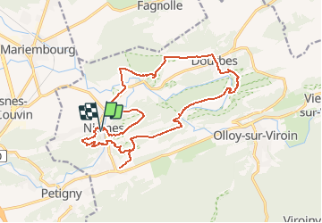

Length
18.3 km

Max alt
237 m

Uphill gradient
516 m
Km-Effort
25 km

Min alt
145 m

Downhill gradient
518 m
Boucle
Yes
Creation date :
2020-07-01 15:39:30.856
Updated on :
2020-07-01 15:40:20.599
5h19
Difficulty : Very difficult

FREE GPS app for hiking
 SityTrail
IGN / Geographical institutes
SityTrail Plus
The world is yours!
About
Trail Walking of 18.3 km to be discovered at Wallonia, Namur, Viroinval. This trail is proposed by etteloc.
Description
Curiosités Géologiques
Positioning
Country:
Belgium
Region :
Wallonia
Department/Province :
Namur
Municipality :
Viroinval
Location:
Nismes
Start:(Dec)
Start:(UTM)
610781 ; 5547979 (31U) N.
Comments