


rando bellefontaine 2/07/2020

japy54
User GUIDE
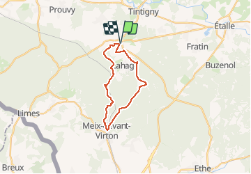

Length
18.7 km

Max alt
373 m

Uphill gradient
325 m
Km-Effort
23 km

Min alt
231 m

Downhill gradient
325 m
Boucle
Yes
Creation date :
2020-07-02 07:06:49.55
Updated on :
2020-07-02 11:39:45.711
4h05
Difficulty : Easy

FREE GPS app for hiking
 SityTrail
IGN / Geographical institutes
SityTrail Plus
The world is yours!
About
Trail Walking of 18.7 km to be discovered at Wallonia, Luxembourg, Tintigny. This trail is proposed by japy54.
Positioning
Country:
Belgium
Region :
Wallonia
Department/Province :
Luxembourg
Municipality :
Tintigny
Location:
Bellefontaine
Start:(Dec)
Start:(UTM)
680135 ; 5503957 (31U) N.
Comments