


clintest
User
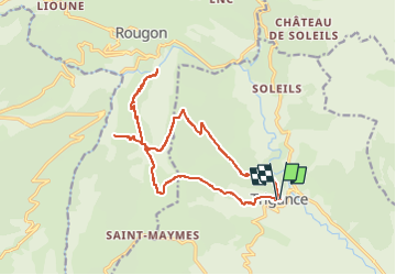

Length
19.1 km

Max alt
1156 m

Uphill gradient
990 m
Km-Effort
32 km

Min alt
624 m

Downhill gradient
978 m
Boucle
Yes
Creation date :
2020-07-02 12:39:05.639
Updated on :
2020-07-02 12:39:05.639

FREE GPS app for hiking
 SityTrail
IGN / Geographical institutes
SityTrail Plus
The world is yours!
About
Trail of 19.1 km to be discovered at Provence-Alpes-Côte d'Azur, Var, Trigance. This trail is proposed by clintest.
Positioning
Country:
France
Region :
Provence-Alpes-Côte d'Azur
Department/Province :
Var
Municipality :
Trigance
Location:
Unknown
Start:(Dec)
Start:(UTM)
294387 ; 4848553 (32T) N.
Comments