


11599386-ZLe Gué de la Chaine 19.10

togolo28
User
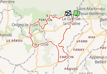

Length
19.1 km

Max alt
197 m

Uphill gradient
284 m
Km-Effort
23 km

Min alt
108 m

Downhill gradient
286 m
Boucle
Yes
Creation date :
2020-07-03 09:33:50.214
Updated on :
2020-07-03 09:34:44.453
--
Difficulty : Medium

FREE GPS app for hiking
 SityTrail
IGN / Geographical institutes
SityTrail Plus
The world is yours!
About
Trail Walking of 19.1 km to be discovered at Normandy, Orne, Belforêt-en-Perche. This trail is proposed by togolo28.
Positioning
Country:
France
Region :
Normandy
Department/Province :
Orne
Municipality :
Belforêt-en-Perche
Location:
Unknown
Start:(Dec)
Start:(UTM)
316548 ; 5360944 (31U) N.
Comments