


La métairie aux moines

laoj
User

Length
6.3 km

Max alt
127 m

Uphill gradient
98 m
Km-Effort
7.6 km

Min alt
75 m

Downhill gradient
99 m
Boucle
Yes
Creation date :
2020-07-04 07:53:47.602
Updated on :
2020-07-04 07:56:03.831
1h39
Difficulty : Medium

FREE GPS app for hiking
 SityTrail
IGN / Geographical institutes
SityTrail Plus
The world is yours!
About
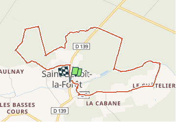
Trail Walking of 6.3 km to be discovered at Centre-Loire Valley, Indre-et-Loire, Saint-Benoît-la-Forêt. This trail is proposed by laoj.
Description
circuit principalement en forêt
Positioning
Country:
France
Region :
Centre-Loire Valley
Department/Province :
Indre-et-Loire
Municipality :
Saint-Benoît-la-Forêt
Location:
Unknown
Start:(Dec)
Start:(UTM)
297281 ; 5233162 (31T) N.
Comments