


NAROUEL

surceneux
User
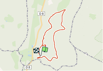

Length
7.8 km

Max alt
997 m

Uphill gradient
219 m
Km-Effort
10.8 km

Min alt
829 m

Downhill gradient
233 m
Boucle
Yes
Creation date :
2020-07-04 13:31:30.535
Updated on :
2020-07-04 16:54:02.129
2h09
Difficulty : Easy

FREE GPS app for hiking
 SityTrail
IGN / Geographical institutes
SityTrail Plus
The world is yours!
About
Trail Walking of 7.8 km to be discovered at Grand Est, Vosges, Gerbépal. This trail is proposed by surceneux.
Description
RF PRE PT JEAN NAROUEL ETANG HTS DES FRETS LA CHAUME PRE PT JEAN RF
Positioning
Country:
France
Region :
Grand Est
Department/Province :
Vosges
Municipality :
Gerbépal
Location:
Unknown
Start:(Dec)
Start:(UTM)
344445 ; 5329575 (32U) N.
Comments