


Chantemelle

Airelle
User
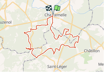

Length
22 km

Max alt
363 m

Uphill gradient
345 m
Km-Effort
26 km

Min alt
266 m

Downhill gradient
345 m
Boucle
Yes
Creation date :
2020-07-05 06:41:04.0
Updated on :
2020-07-05 13:52:30.864
4h45
Difficulty : Unknown

FREE GPS app for hiking
 SityTrail
IGN / Geographical institutes
SityTrail Plus
The world is yours!
About
Trail Walking of 22 km to be discovered at Wallonia, Luxembourg, Étalle. This trail is proposed by Airelle.
Positioning
Country:
Belgium
Region :
Wallonia
Department/Province :
Luxembourg
Municipality :
Étalle
Location:
Chantemelle
Start:(Dec)
Start:(UTM)
691436 ; 5503505 (31U) N.
Comments