


autour de wallon

domheitz
User
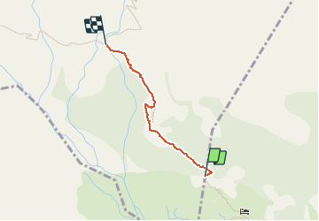

Length
876 m

Max alt
2048 m

Uphill gradient
130 m
Km-Effort
2.2 km

Min alt
1906 m

Downhill gradient
0 m
Boucle
No
Creation date :
2020-07-05 08:43:25.502
Updated on :
2020-07-05 19:36:41.732
43m
Difficulty : Medium

FREE GPS app for hiking
 SityTrail
IGN / Geographical institutes
SityTrail Plus
The world is yours!
About
Trail Walking of 876 m to be discovered at Occitania, Hautespyrenees, Estaing. This trail is proposed by domheitz.
Positioning
Country:
France
Region :
Occitania
Department/Province :
Hautespyrenees
Municipality :
Estaing
Location:
Unknown
Start:(Dec)
Start:(UTM)
729166 ; 4744790 (30T) N.
Comments