


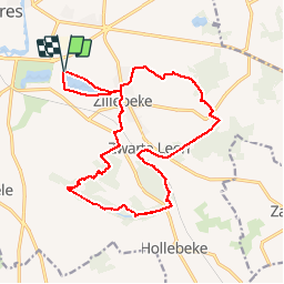
ypres 17 km

rvapeldo
User GUIDE

Length
17.3 km

Max alt
67 m

Uphill gradient
168 m
Km-Effort
19.5 km

Min alt
22 m

Downhill gradient
168 m
Boucle
Yes
Creation date :
2018-10-06 08:31:47.604
Updated on :
2018-10-06 08:31:47.662
4h15
Difficulty : Very easy

FREE GPS app for hiking
 SityTrail
IGN / Geographical institutes
SityTrail Plus
The world is yours!
About
Trail Walking of 17.3 km to be discovered at Flanders, West Flanders, Ypres. This trail is proposed by rvapeldo.
Description
Balade au sud d'Ypres, dans des zones boisées, des collines légères et à travers quelques hauts lieux de la 1ère guerre mondiale (cimetières du Commenwealth, Cote 60 et 62).
Positioning
Country:
Belgium
Region :
Flanders
Department/Province :
West Flanders
Municipality :
Ypres
Location:
Ypres
Start:(Dec)
Start:(UTM)
493280 ; 5632058 (31U) N.
Comments