caply SityTrail > Trails > Outdoor > France > Hauts-de-France > Oise > Saint-André-Farivillers SityTrail > Trails > Outdoor > France > Hauts-de-France > Oise > Saint-André-Farivillers caply lefrancm User 3D © OpenStreetMap contributors Length 3.4 km Max alt 138 m Uphill gradient 40 m Km-Effort 3.9 km Min alt 104 m Downhill gradient 39 m Boucle Yes Creation date : 2014-12-10 00:00:00.0 Updated on : 2014-12-10 00:00:00.0 (0 Reviews) Walking 52m Difficulty : Very easy FREE GPS app for hiking SityTrail IGN / Geographical institutes SityTrail World The world is yours! About 
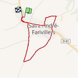
Trail Walking of 3.4 km to be discovered at Hauts-de-France, Oise, Saint-André-Farivillers. This trail is proposed by lefrancm. Description balade autour du village de Caply Legends | More details (PDF) Elevation profile Legends > 15% 15% - 10% 10% - 5% flat 5% - 10% 10% - 15% 15% - 30% > 30% Positioning Country: France Region : Hauts-de-France Department/Province : Oise Municipality : Saint-André-Farivillers Location: Unknown Start:(Dec) 49.588272 / 2.286941 Start:(UTM) 448462 ; 5493099 (31U) N. Comments Please log in to post a review or rate the element Trails nearby jpblimond Hardivillers Walking Easy Hardivillers, Hauts-de-France, Oise, France 15.6 km | 17.4 km-effort 3h 48min Yes