


SityTrail - tet gallardon

olivieraron
User
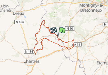

Length
120 km

Max alt
177 m

Uphill gradient
1147 m
Km-Effort
135 km

Min alt
95 m

Downhill gradient
1143 m
Boucle
Yes
Creation date :
2020-07-07 05:09:52.764
Updated on :
2020-07-07 07:29:50.6
--
Difficulty : Very easy

FREE GPS app for hiking
 SityTrail
IGN / Geographical institutes
SityTrail Plus
The world is yours!
About
Trail Motorbike of 120 km to be discovered at Ile-de-France, Yvelines, Émancé. This trail is proposed by olivieraron.
Positioning
Country:
France
Region :
Ile-de-France
Department/Province :
Yvelines
Municipality :
Émancé
Location:
Unknown
Start:(Dec)
Start:(UTM)
406428 ; 5382800 (31U) N.
Comments