


pichoux

danif
User
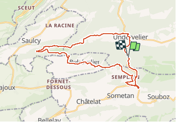

Length
18.6 km

Max alt
1041 m

Uphill gradient
721 m
Km-Effort
28 km

Min alt
533 m

Downhill gradient
728 m
Boucle
Yes
Creation date :
2020-07-07 07:43:28.132
Updated on :
2020-07-07 16:22:15.365
7h18
Difficulty : Very easy

FREE GPS app for hiking
 SityTrail
IGN / Geographical institutes
SityTrail Plus
The world is yours!
About
Trail Walking of 18.6 km to be discovered at Jura, District de Delémont, Haute-Sorne. This trail is proposed by danif.
Positioning
Country:
Switzerland
Region :
Jura
Department/Province :
District de Delémont
Municipality :
Haute-Sorne
Location:
Unknown
Start:(Dec)
Start:(UTM)
365618 ; 5239297 (32T) N.
Comments