


Mont St Odile

LauVan
User
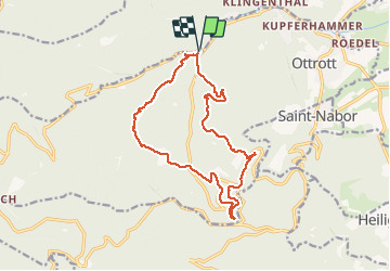

Length
15.3 km

Max alt
772 m

Uphill gradient
625 m
Km-Effort
24 km

Min alt
343 m

Downhill gradient
625 m
Boucle
Yes
Creation date :
2020-07-05 08:33:23.298
Updated on :
2020-07-07 16:27:49.04
5h41
Difficulty : Easy

FREE GPS app for hiking
 SityTrail
IGN / Geographical institutes
SityTrail Plus
The world is yours!
About
Trail Walking of 15.3 km to be discovered at Grand Est, Bas-Rhin, Ottrott. This trail is proposed by LauVan.
Positioning
Country:
France
Region :
Grand Est
Department/Province :
Bas-Rhin
Municipality :
Ottrott
Location:
Unknown
Start:(Dec)
Start:(UTM)
380755 ; 5368589 (32U) N.
Comments