


Très difficile

Doubotis
User ADMIN
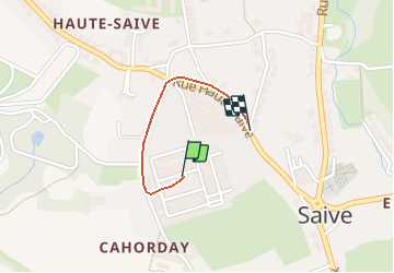

Length
743 m

Max alt
196 m

Uphill gradient
1 m
Km-Effort
793 m

Min alt
184 m

Downhill gradient
12 m
Boucle
No
Creation date :
2020-07-08 12:24:32.0
Updated on :
2020-07-08 12:27:24.238
2m
Difficulty :

FREE GPS app for hiking
 SityTrail
IGN / Geographical institutes
SityTrail Plus
The world is yours!
About
Trail Walking of 743 m to be discovered at Wallonia, Liège, Blegny. This trail is proposed by Doubotis.
Positioning
Country:
Belgium
Region :
Wallonia
Department/Province :
Liège
Municipality :
Blegny
Location:
Saive
Start:(Dec)
Start:(UTM)
689186 ; 5614714 (31U) N.
Comments
Tu
En effet très difficile