


track

bubuserge
User

Length
14.8 km

Max alt
78 m

Uphill gradient
231 m
Km-Effort
17.8 km

Min alt
14 m

Downhill gradient
231 m
Boucle
Yes
Creation date :
2020-07-08 14:38:26.318
Updated on :
2020-07-08 14:40:55.723
3h52
Difficulty : Difficult

FREE GPS app for hiking
 SityTrail
IGN / Geographical institutes
SityTrail Plus
The world is yours!
About
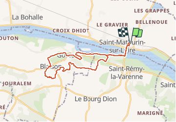
Trail Walking of 14.8 km to be discovered at Pays de la Loire, Maine-et-Loire, Loire-Authion. This trail is proposed by bubuserge.
Positioning
Country:
France
Region :
Pays de la Loire
Department/Province :
Maine-et-Loire
Municipality :
Loire-Authion
Location:
Saint-Mathurin-sur-Loire
Start:(Dec)
Start:(UTM)
702521 ; 5254327 (30T) N.
Comments