


Nantes lochmariaker

Rangabe
User

Length
48 km

Max alt
226 m

Uphill gradient
480 m
Km-Effort
55 km

Min alt
3 m

Downhill gradient
664 m
Boucle
No
Creation date :
2020-06-24 08:57:50.228
Updated on :
2020-07-09 13:29:23.897
4h58
Difficulty : Very easy

FREE GPS app for hiking
 SityTrail
IGN / Geographical institutes
SityTrail Plus
The world is yours!
About
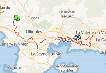
Trail Plane of 48 km to be discovered at Provence-Alpes-Côte d'Azur, Var, Sanary-sur-Mer. This trail is proposed by Rangabe.
Positioning
Country:
France
Region :
Provence-Alpes-Côte d'Azur
Department/Province :
Var
Municipality :
Sanary-sur-Mer
Location:
Unknown
Start:(Dec)
Start:(UTM)
727652 ; 4781438 (31T) N.
Comments