


la goulandiere

jphugon
User
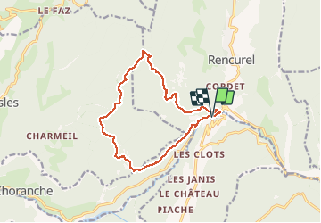

Length
14.8 km

Max alt
1373 m

Uphill gradient
790 m
Km-Effort
25 km

Min alt
657 m

Downhill gradient
790 m
Boucle
Yes
Creation date :
2020-07-09 06:56:57.075
Updated on :
2020-07-09 14:40:57.742
7h42
Difficulty : Medium

FREE GPS app for hiking
 SityTrail
IGN / Geographical institutes
SityTrail Plus
The world is yours!
About
Trail Walking of 14.8 km to be discovered at Auvergne-Rhône-Alpes, Isère, Rencurel. This trail is proposed by jphugon.
Positioning
Country:
France
Region :
Auvergne-Rhône-Alpes
Department/Province :
Isère
Municipality :
Rencurel
Location:
Unknown
Start:(Dec)
Start:(UTM)
693979 ; 4995615 (31T) N.
Comments