


Promenade de la cascade

so.duchateau
User

Length
11.1 km

Max alt
1612 m

Uphill gradient
466 m
Km-Effort
17.3 km

Min alt
1210 m

Downhill gradient
464 m
Boucle
Yes
Creation date :
2020-07-09 12:20:16.0
Updated on :
2020-07-09 15:31:47.56
3h11
Difficulty : Medium

FREE GPS app for hiking
 SityTrail
IGN / Geographical institutes
SityTrail Plus
The world is yours!
About
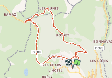
Trail Walking of 11.1 km to be discovered at Auvergne-Rhône-Alpes, Upper Savoy, Taninges. This trail is proposed by so.duchateau.
Description
Allez simple depuis Praz-de-Lys au col de la Ramaz
Photos


Positioning
Country:
France
Region :
Auvergne-Rhône-Alpes
Department/Province :
Upper Savoy
Municipality :
Taninges
Location:
Unknown
Start:(Dec)
Start:(UTM)
314616 ; 5112882 (32T) N.
Comments