Trail Mountain bike Théoule-sur-Mer - 20200716-v1 VTT Cap Roux - Photo
 cuvette
cuvette

User

© OpenStreetMap contributors
Length
Length
29 km
Max alt
Max alt
331 m
Uphill gradient
Uphill gradient
731 m
Km-Effort
Km-Effort  
39 km
Min alt
Min alt
10 m
Downhill gradient
Downhill gradient
731 m
Boucle
Boucle
Yes
Creation date :
2020-07-01 04:36:47.203
Updated on :
2020-07-09 18:05:29.445

(1 Reviews)

Mountain bike
Mountain bike
2h01
Difficulty : Medium

Scan this QR Code to open this trail in the SityTrail application

FREE GPS app for hiking

Logo SityTrail SityTrail

IGN / Geographical institutes

Download SityTrail from the App Store Download SityTrail from Google Play

Logo SityTrail SityTrail World

The world is yours!

Download SityTrail from the App Store Download SityTrail from Google Play Download SityTrail on Huawei AppGallery

About

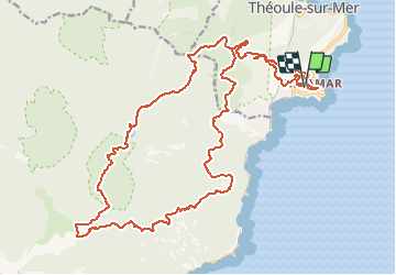
Trail Mountain bike of 29 km to be discovered at Provence-Alpes-Côte d'Azur, Maritime Alps, Théoule-sur-Mer. This trail is proposed by cuvette.

Elevation profile

Points of interest

Point of interest Saint-Raphaël - Chapelle - Grotte de Saint Honorat - Photo
cuvette
Point of interest Saint-Raphaël - Ancien Lac de l'Écureuil - Photo
cuvette

Positioning

Country:
France
Region :
Provence-Alpes-Côte d'Azur
Department/Province :
Maritime Alps
Municipality :
Théoule-sur-Mer
Location:
Unknown
Start:(UTM)
333436 ; 4817040 (32T) N.

Comments

Please log in to post a review or rate the element


quelques passages inaccessibles à cause de la végétation envahissante ou périlleux. c'est dommage car magnifique parcours.


Trails nearby

Trail Walking Saint-Raphaël - Massif d'ésterel-grande boucle pic cap roux - Photo
Walking
jeromelacoste

Walking

Medium
(2)
Saint-Raphaël, Provence-Alpes-Côte d'Azur, Var, France
10.4 km | 17.5 km-effort
2h 58min
Yes
Trail Walking Saint-Raphaël - Le tour du Pic du Cap Roux - St Raphaël (Agay) - Photo
Walking
tracegps

Walking

Medium
(2)
Saint-Raphaël, Provence-Alpes-Côte d'Azur, Var, France
7.2 km | 12.8 km-effort
2h 0min
Yes
Trail Walking Saint-Raphaël - Pic du Cap Roux - Photo
Walking
Kilroy06

Walking

Very easy
(4)
Saint-Raphaël, Provence-Alpes-Côte d'Azur, Var, France
4.1 km | 7.8 km-effort
1h 17min
Yes
Trail Walking Mandelieu-la-Napoule - Mont Saint Martin - Photo
Walking
Kilroy06

Walking

Easy
(1)
Mandelieu-la-Napoule, Provence-Alpes-Côte d'Azur, Maritime Alps, France
9 km | 14.2 km-effort
3h 0min
Yes
Trail Walking Saint-Raphaël - Tour du Pic de l'Ours - Le Trayas - Photo
Walking
tracegps

Walking

Medium
(1)
Saint-Raphaël, Provence-Alpes-Côte d'Azur, Var, France
9.5 km | 16 km-effort
3h 0min
Yes
Trail Walking Saint-Raphaël - Circuit Esterel Rocher St Barthelemy, Chapelle et Cap Roux - Photo
Walking
GrouGary

Walking

Very easy
(1)
Saint-Raphaël, Provence-Alpes-Côte d'Azur, Var, France
11.4 km | 19.8 km-effort
3h 51min
Yes
Trail On foot Théoule-sur-Mer - Tracé Rocher des Monges par col de Théoule - Photo
On foot
Sylvie Cagnes

On foot

Very easy
(1)
Théoule-sur-Mer, Provence-Alpes-Côte d'Azur, Maritime Alps, France
7.2 km | 11.2 km-effort
Unknown
Yes
Trail Walking Saint-Raphaël - pic de l'ours pic d' aurelle - Photo
Walking
puchol

Walking

Medium
(2)
Saint-Raphaël, Provence-Alpes-Côte d'Azur, Var, France
10.8 km | 17.7 km-effort
4h 3min
Yes
Trail Walking Théoule-sur-Mer - Théoule - Col de Théoule - ND d'Afrique - Pointe de L'Aiguille - Photo
Walking
LtZIP

Walking

Easy
Théoule-sur-Mer, Provence-Alpes-Côte d'Azur, Maritime Alps, France
9.9 km | 14.9 km-effort
3h 23min
Yes


Close
My subscriptions