


Vendredi AM Col de Vars

jcm17
User
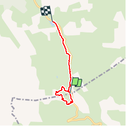

Length
4.5 km

Max alt
2170 m

Uphill gradient
77 m
Km-Effort
5.9 km

Min alt
1989 m

Downhill gradient
194 m
Boucle
No
Creation date :
2014-12-10 00:00:00.0
Updated on :
2014-12-10 00:00:00.0
1h56
Difficulty : Easy

FREE GPS app for hiking
 SityTrail
IGN / Geographical institutes
SityTrail Plus
The world is yours!
About
Trail Snowshoes of 4.5 km to be discovered at Provence-Alpes-Côte d'Azur, Hautes-Alpes, Vars. This trail is proposed by jcm17.
Description
Tour au Col de Vars vers l’igloo puis la Chapelle Ste Marie-Madeleine, suivi d'une descente jusqu'au Refuge Napoléon?


Positioning
Country:
France
Region :
Provence-Alpes-Côte d'Azur
Department/Province :
Hautes-Alpes
Municipality :
Vars
Location:
Unknown
Start:(Dec)
Start:(UTM)
317451 ; 4934303 (32T) N.
Comments