


RB-Ste_Baume

raymondfn
User


4h33
Difficulty : Medium

FREE GPS app for hiking
 SityTrail
IGN / Geographical institutes
SityTrail Plus
The world is yours!
About
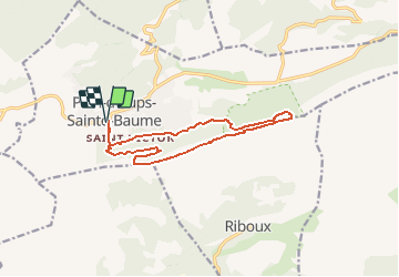
Trail Walking of 13.7 km to be discovered at Provence-Alpes-Côte d'Azur, Var, Plan-d'Aups-Sainte-Baume. This trail is proposed by raymondfn.
Description
Plan d'Aups, l'Ubac, Pas de Roubaud, Grotte aux Oeufs, grotte Marie-Madeleine, chapelle des Parisiens, col du Saint-Pilon, Saint-Pilon, Pas de la Cabre, vallon de Betton, l'Ubac, Plan d'Aups.
Positioning
Comments