


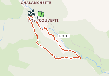
Boucle La Fruitiere

seghth
User

Length
3.7 km

Max alt
1971 m

Uphill gradient
151 m
Km-Effort
5.7 km

Min alt
1820 m

Downhill gradient
153 m
Boucle
Yes
Creation date :
2020-07-10 13:47:21.695
Updated on :
2020-07-10 21:07:31.154
1h34
Difficulty : Very easy

FREE GPS app for hiking
 SityTrail
IGN / Geographical institutes
SityTrail Plus
The world is yours!
About
Trail Walking of 3.7 km to be discovered at Provence-Alpes-Côte d'Azur, Hautes-Alpes, Névache. This trail is proposed by seghth.
Positioning
Country:
France
Region :
Provence-Alpes-Côte d'Azur
Department/Province :
Hautes-Alpes
Municipality :
Névache
Location:
Unknown
Start:(Dec)
Start:(UTM)
306748 ; 4989556 (32T) N.
Comments