


seb

François Dardenne
User
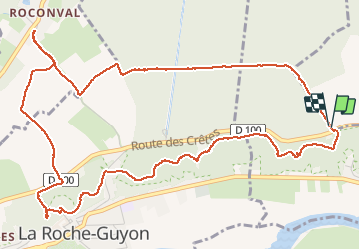

Length
6.8 km

Max alt
132 m

Uphill gradient
224 m
Km-Effort
9.8 km

Min alt
28 m

Downhill gradient
218 m
Boucle
Yes
Creation date :
2020-07-12 10:20:05.533
Updated on :
2020-07-12 13:17:07.564
2h35
Difficulty : Very easy

FREE GPS app for hiking
 SityTrail
IGN / Geographical institutes
SityTrail Plus
The world is yours!
About
Trail Walking of 6.8 km to be discovered at Ile-de-France, Val-d'Oise, Chérence. This trail is proposed by François Dardenne.
Positioning
Country:
France
Region :
Ile-de-France
Department/Province :
Val-d'Oise
Municipality :
Chérence
Location:
Unknown
Start:(Dec)
Start:(UTM)
401571 ; 5438006 (31U) N.
Comments