


Saint Hubert

francoisecarlier
User
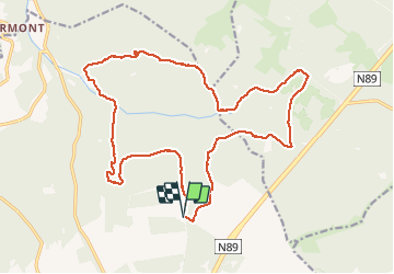

Length
21 km

Max alt
574 m

Uphill gradient
516 m
Km-Effort
27 km

Min alt
325 m

Downhill gradient
516 m
Boucle
Yes
Creation date :
2020-07-12 09:10:24.0
Updated on :
2020-07-12 14:00:11.559
4h25
Difficulty : Medium

FREE GPS app for hiking
 SityTrail
IGN / Geographical institutes
SityTrail Plus
The world is yours!
About
Trail Walking of 21 km to be discovered at Wallonia, Luxembourg, Saint-Hubert. This trail is proposed by francoisecarlier.
Positioning
Country:
Belgium
Region :
Wallonia
Department/Province :
Luxembourg
Municipality :
Saint-Hubert
Location:
Saint-Hubert
Start:(Dec)
Start:(UTM)
670406 ; 5547216 (31U) N.
Comments