


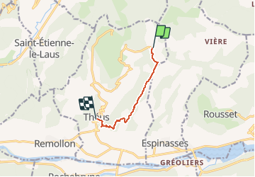
Descente Mont Colombis - Theus

mthomas30
User

Length
5.6 km

Max alt
1736 m

Uphill gradient
95 m
Km-Effort
9.5 km

Min alt
841 m

Downhill gradient
887 m
Boucle
No
Creation date :
2020-07-12 13:52:34.623
Updated on :
2020-07-13 06:40:53.853
43m
Difficulty : Medium

FREE GPS app for hiking
 SityTrail
IGN / Geographical institutes
SityTrail Plus
The world is yours!
About
Trail Mountain bike of 5.6 km to be discovered at Provence-Alpes-Côte d'Azur, Hautes-Alpes, Théus. This trail is proposed by mthomas30.
Positioning
Country:
France
Region :
Provence-Alpes-Côte d'Azur
Department/Province :
Hautes-Alpes
Municipality :
Théus
Location:
Unknown
Start:(Dec)
Start:(UTM)
278655 ; 4931255 (32T) N.
Comments