


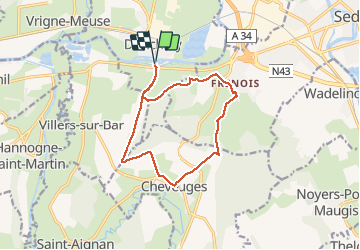
Boucle de la croix piot, depuis Donchery

michelelfn
User


3h42
Difficulty : Medium

FREE GPS app for hiking
 SityTrail
IGN / Geographical institutes
SityTrail Plus
The world is yours!
About
Trail Walking of 11.8 km to be discovered at Grand Est, Ardennes, Donchery. This trail is proposed by michelelfn.
Description
Balade sur les hauteurs du Sedanais, alternant les bois, les champs et les points de vue ; peu de bitume. Pour les photos, il vaudrait mieux faire le parcours le matin.
Possibilité de rejoindre les nécropoles de Noyers Pont Maugis - tourner à gauche au lieu de descendre sur Cheveuges. 4km pour l'AR.
Positioning
Comments