


cuvery catray boucle

ppn
User
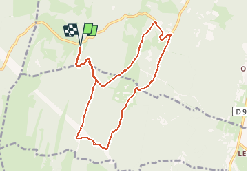

Length
10 km

Max alt
1246 m

Uphill gradient
245 m
Km-Effort
13.3 km

Min alt
1052 m

Downhill gradient
245 m
Boucle
Yes
Creation date :
2020-07-12 11:02:39.714
Updated on :
2020-07-12 17:01:27.641
2h48
Difficulty : Very easy

FREE GPS app for hiking
 SityTrail
IGN / Geographical institutes
SityTrail Plus
The world is yours!
About
Trail Walking of 10 km to be discovered at Auvergne-Rhône-Alpes, Ain, Valserhône. This trail is proposed by ppn.
Positioning
Country:
France
Region :
Auvergne-Rhône-Alpes
Department/Province :
Ain
Municipality :
Valserhône
Location:
Châtillon-en-Michaille
Start:(Dec)
Start:(UTM)
711391 ; 5110030 (31T) N.
Comments