


cascade de l'Oulette

CatherinePerrin
User
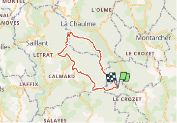

Length
13.9 km

Max alt
1199 m

Uphill gradient
412 m
Km-Effort
19.3 km

Min alt
931 m

Downhill gradient
408 m
Boucle
Yes
Creation date :
2020-07-12 11:35:21.194
Updated on :
2020-07-12 17:30:42.946
5h52
Difficulty : Very easy

FREE GPS app for hiking
 SityTrail
IGN / Geographical institutes
SityTrail Plus
The world is yours!
About
Trail Walking of 13.9 km to be discovered at Auvergne-Rhône-Alpes, Loire, Estivareilles. This trail is proposed by CatherinePerrin.
Positioning
Country:
France
Region :
Auvergne-Rhône-Alpes
Department/Province :
Loire
Municipality :
Estivareilles
Location:
Unknown
Start:(Dec)
Start:(UTM)
575957 ; 5031692 (31T) N.
Comments