Trail Motor Waterloo - RN_WH - Photo
 OPT
OPT

User

© OpenStreetMap contributors
Length
Length
88 km
Max alt
Max alt
232 m
Uphill gradient
Uphill gradient
940 m
Km-Effort
Km-Effort  
101 km
Min alt
Min alt
101 m
Downhill gradient
Downhill gradient
892 m
Boucle
Boucle
No
Creation date :
2014-12-10 00:00:00.0
Updated on :
2014-12-10 00:00:00.0

(1 Reviews)

Motor
Motor
2h00
Difficulty : Medium

Scan this QR Code to open this trail in the SityTrail application

FREE GPS app for hiking

Logo SityTrail SityTrail

IGN / Geographical institutes

Download SityTrail from the App Store Download SityTrail from Google Play

Logo SityTrail SityTrail World

The world is yours!

Download SityTrail from the App Store Download SityTrail from Google Play Download SityTrail on Huawei AppGallery

About

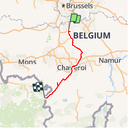
Trail Motor of 88 km to be discovered at Wallonia, Walloon Brabant, Waterloo. This trail is proposed by OPT.

Description

Route Napoléon - RN_WH

Elevation profile

Points of interest

Point of interest Genappe - FIG 51 - Photo
OPT
GENAPPE 
Point of interest Genappe - FIG 53- 54- ?? - Photo
OPT
Point of interest Waterloo - FIG 55 - Photo
OPT
WATERLOO 
Point of interest Lasne - FIG 69 - Photo
OPT
LASNE 
Point of interest Ham-sur-Heure-Nalinnes - Géolocalisation Chapelle Saint-Roch - Photo
OPT
HAM-SUR-HEURE-NALINNES 
Point of interest Ham-sur-Heure-Nalinnes - Géolocalisation église Saint-André - Photo
OPT
HAM-SUR-HEURE-NALINNES 
Point of interest Braine-l’Alleud - Géolocalisation Ferme de la Haie Sainte - Photo
OPT
Point of interest Lasne - HISTORIQUE - Photo
OPT
LASNE 
Point of interest Ham-sur-Heure-Nalinnes - Historique chapelle Saint-Roch - Photo
OPT
HAM-SUR-HEURE-NALINNES 
Point of interest Villers-la-Ville - HISTORIQUE Napoléon' - Photo
OPT
VILLERS-LA-VILLE 
Point of interest Beaumont - HISTORIQUE stèle - Photo
OPT
Point of interest Beaumont - La marzel - Photo
OPT
BEAUMONT 
Point of interest Charleroi - Site bois du Cazier - Photo
OPT
Point of interest Villers-la-Ville - Site de l' Abbaye De Villers - Photo
OPT
Point of interest Ham-sur-Heure-Nalinnes - Site de la chapelle Saint-Roch - Photo
OPT
HAM-SUR-HEURE-NALINNES 
Point of interest Ham-sur-Heure-Nalinnes - Site de l'église Saint-André - Photo
OPT
HAM-SUR-HEURE-NALINNES 

Positioning

Country:
Belgium
Region :
Wallonia
Department/Province :
Walloon Brabant
Municipality :
Waterloo
Location:
Waterloo
Start:(UTM)
599688 ; 5615229 (31U) N.

Comments

Please log in to post a review or rate the element


Trails nearby

Trail Walking Braine-l’Alleud - RB-Bw-13_Braine-l'Alleud - Photo
Walking
PRO

Walking

Very difficult
(5)
Braine-l’Alleud, Wallonia, Walloon Brabant, Belgium
21 km | 27 km-effort
6h 2min
Yes
Trail Walking Braine-l’Alleud - RB-Bw-13 - Raccourci - Le Hain entre deux Braines - Photo
Walking
PRO

Walking

Difficult
(6)
Braine-l’Alleud, Wallonia, Walloon Brabant, Belgium
14.8 km | 18.8 km-effort
4h 16min
Yes
Trail Mountain bike Braine-l’Alleud - O2bikers_58_Waterloo - Photo
Mountain bike
GUIDE+

Mountain bike

Very easy
(5)
Braine-l’Alleud, Wallonia, Walloon Brabant, Belgium
30 km | 37 km-effort
4h 11min
Yes
Trail Mountain bike Lasne - maransart - Photo
Mountain bike
GUIDE
pascalou73

Mountain bike

Difficult
(1)
Lasne, Wallonia, Walloon Brabant, Belgium
40 km | 49 km-effort
Unknown
Yes
Trail Mountain bike Lasne - VTT a plancenoit - Photo
Mountain bike
GUIDE
pascalou73

Mountain bike

Difficult
(1)
Lasne, Wallonia, Walloon Brabant, Belgium
28 km | 34 km-effort
2h 20min
Yes
Trail Mountain bike Waterloo - De Waterloo à la forêt de Soignes - Photo
Mountain bike
GUIDE
pascalou73

Mountain bike

Medium
(1)
Waterloo, Wallonia, Walloon Brabant, Belgium
39 km | 47 km-effort
3h 1min
Yes
Trail Walking Lasne - #240315 - Ohain Golf de Waterloo Marache - Photo
Walking
Randos Ouvertes

Walking

Medium
(1)
Lasne, Wallonia, Walloon Brabant, Belgium
6.3 km | 7.4 km-effort
1h 41min
Yes
Trail Walking Braine-l’Alleud - #221003 - Braine-l'Alleud, Timpe et Tard et Bois du Foriest, Parc et Lac du Paradis*** - Photo
Walking
Randos Ouvertes

Walking

Medium
(1)
Braine-l’Alleud, Wallonia, Walloon Brabant, Belgium
8.1 km | 9.8 km-effort
2h 13min
Yes
Trail Walking Lasne - RB 11 Plancenoit - Lasnes - Photo
Walking
jregin

Walking

Easy
(1)
Lasne, Wallonia, Walloon Brabant, Belgium
12.8 km | 15.6 km-effort
2h 42min
Yes


Close
My subscriptions