Trail Walking Long - Une randonnée rythmée par les étangs. - Photo

Une randonnée rythmée par les étangs.

© OpenStreetMap contributors
Length
Length
6.7 km
Max alt
Max alt
15 m
Uphill gradient
Uphill gradient
33 m
Km-Effort
Km-Effort  
7.1 km
Min alt
Min alt
4 m
Downhill gradient
Downhill gradient
34 m
Boucle
Boucle
No
Creation date :
2020-07-13 08:40:25.952
Updated on :
2020-07-18 10:49:36.524

(0 Reviews)

Walking
Walking
1h53
Difficulty : Very easy

Scan this QR Code to open this trail in the SityTrail application

FREE GPS app for hiking

Logo SityTrail SityTrail

IGN / Geographical institutes

Download SityTrail from the App Store Download SityTrail from Google Play

Logo SityTrail SityTrail World

The world is yours!

Download SityTrail from the App Store Download SityTrail from Google Play Download SityTrail on Huawei AppGallery

About

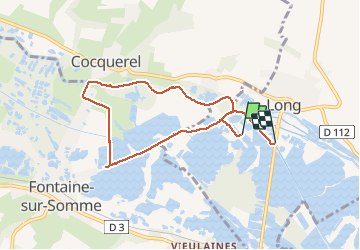
Trail Walking of 6.7 km to be discovered at Hauts-de-France, Somme, Long. This trail is proposed by Luc Gengoux.

Description

Plus une balade qu'une randonnée, à chaque étang une découverte. La faune et la flore nous en font voir de toutes les couleurs.

Elevation profile

Photos

Positioning

Country:
France
Region :
Hauts-de-France
Department/Province :
Somme
Municipality :
Long
Location:
Unknown
Start:(UTM)
426403 ; 5543128 (31U) N.

Trails nearby

Trail Walking Long - L'écluse et la centrale hydroélectrique  -  Long - Photo
Walking
tracegps

Walking

Easy
(1)
Long, Hauts-de-France, Somme, France
2.4 km | 2.6 km-effort
30min
Yes
Trail Walking Long - long bleue 9km - Photo
Walking
fif59280

Walking

Medium
Long, Hauts-de-France, Somme, France
9.4 km | 10.2 km-effort
2h 3min
No
Trail On foot Condé-Folie - Les Marais de Condé-Folie - Photo
On foot
PRO

On foot

Easy
Condé-Folie, Hauts-de-France, Somme, France
5.4 km | 5.7 km-effort
1h 18min
Yes
Trail On foot Longpré-les-Corps-Saints - Le Circuit des Cours d'Eau - Photo
On foot
PRO

On foot

Easy
Longpré-les-Corps-Saints, Hauts-de-France, Somme, France
4.9 km | 5.2 km-effort
1h 11min
Yes
Trail On foot Long - Les Bords de Somme - Photo
On foot
PRO

On foot

Easy
Long, Hauts-de-France, Somme, France
7.9 km | 8.4 km-effort
1h 54min
Yes
Trail On foot Fontaine-sur-Somme - Les Hauts de Long - Photo
On foot
PRO

On foot

Easy
Fontaine-sur-Somme, Hauts-de-France, Somme, France
9.1 km | 11 km-effort
2h 29min
Yes
Trail Walking Pont-Remy - chemin de hallage et crête.  - Photo
Walking
Luc Gengoux

Walking

Very easy
Pont-Remy, Hauts-de-France, Somme, France
9.8 km | 11.6 km-effort
2h 34min
Yes
Trail Walking Longpré-les-Corps-Saints - Le circuit des cours d'eau - Longpré les Corps Saints - Photo
Walking
tracegps

Walking

Medium
(1)
Longpré-les-Corps-Saints, Hauts-de-France, Somme, France
4.9 km | 5.2 km-effort
1h 30min
Yes
Trail Mountain bike Long - Circuit autour de Long - Photo
Mountain bike
tracegps

Mountain bike

Difficult
Long, Hauts-de-France, Somme, France
30 km | 35 km-effort
3h 0min
Yes


Close
My subscriptions