


Authume_Mont Roland 20200713

cmike39
User
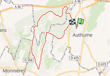

Length
9.4 km

Max alt
346 m

Uphill gradient
219 m
Km-Effort
12.4 km

Min alt
255 m

Downhill gradient
222 m
Boucle
Yes
Creation date :
2020-07-13 15:22:35.099
Updated on :
2020-07-13 17:26:40.178
2h00
Difficulty : Very easy

FREE GPS app for hiking
 SityTrail
IGN / Geographical institutes
SityTrail Plus
The world is yours!
About
Trail Walking of 9.4 km to be discovered at Bourgogne-Franche-Comté, Jura, Authume. This trail is proposed by cmike39.
Positioning
Country:
France
Region :
Bourgogne-Franche-Comté
Department/Province :
Jura
Municipality :
Authume
Location:
Unknown
Start:(Dec)
Start:(UTM)
689511 ; 5222347 (31T) N.
Comments