


SityTrail - MIN 2020 J1 ADV

olivieraron
User
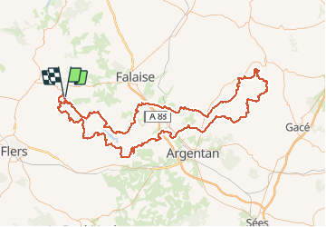

Length
175 km

Max alt
277 m

Uphill gradient
2894 m
Km-Effort
213 km

Min alt
56 m

Downhill gradient
2899 m
Boucle
Yes
Creation date :
2020-07-13 20:30:26.85
Updated on :
2020-07-13 20:33:44.185
5h00
Difficulty : Very easy

FREE GPS app for hiking
 SityTrail
IGN / Geographical institutes
SityTrail Plus
The world is yours!
About
Trail Motorbike of 175 km to be discovered at Normandy, Orne, Ménil-Hubert-sur-Orne. This trail is proposed by olivieraron.
Positioning
Country:
France
Region :
Normandy
Department/Province :
Orne
Municipality :
Ménil-Hubert-sur-Orne
Location:
Unknown
Start:(Dec)
Start:(UTM)
689853 ; 5414544 (30U) N.
Comments