


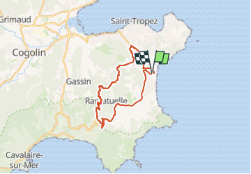
VTT - mataranne - colebasse - paillas - val de rian - mataranne

affinetataille
User GUIDE

Length
24 km

Max alt
265 m

Uphill gradient
455 m
Km-Effort
30 km

Min alt
3 m

Downhill gradient
457 m
Boucle
Yes
Creation date :
2020-07-14 06:21:03.701
Updated on :
2024-08-14 18:14:25.563
2h30
Difficulty : Medium

FREE GPS app for hiking
 SityTrail
IGN / Geographical institutes
SityTrail Plus
The world is yours!
About
Trail Mountain bike of 24 km to be discovered at Provence-Alpes-Côte d'Azur, Var, Ramatuelle. This trail is proposed by affinetataille.
Positioning
Country:
France
Region :
Provence-Alpes-Côte d'Azur
Department/Province :
Var
Municipality :
Ramatuelle
Location:
Unknown
Start:(Dec)
Start:(UTM)
309866 ; 4789539 (32T) N.
Comments